
Liverpool - Southport Line: Waterloo - Seaforth & Litherland
(Merseyrail Northern Line)
Our journey today starts at Southport Chapel Street and follows the line to the site of the erstwhile Liverpool Exchange using Google Streetview images. Should you use the individual Google navigation tools, and wish to restore the page to its default views, just refresh the page.
As it takes a few seconds for each of the Google maps to be retrieved, the line is broken into sections, and generally these are station-to-station. Each Google Streetview image is presented facing the direction of travel, in this case southwards. The intention is that to see the northwards view, the Google navigation tool needs to be used.
The line passes under Brook Vale bridge, built on a skew.
The approaches to Seaforth & Litherland have changed significantly in recent years with a dual carriageway cutting through the embankment, forcing the railway onto two new bridges, the tracks splitting here to pass either side of the island platform.
The entrance to Seaforth & Litherland Station was always low key, and even today you might well miss it.
This view from Akenside Street is a reminder of past glories. The line from Seaforth and Litherland southwards was quadrupled, with the western tracks at Seaforth being used by the Liverpool Overhead Railway trains. They then passed under the North Mersey branch to arrive at this point, with the brick bridge in the background carrying the tracks froswinging down from Aintree, whilst the abutments show where the goods lines have been removed.
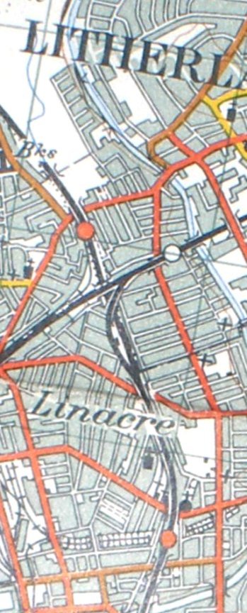
Reproduced from the 1961 Ordnance Survey map.
Copyright J K Wallace, t/a 'Hall Royd Junction' 2013-2023 email: Hall Royd Junction
7 Portobello Close, Chesham, Bucks. HP5 2PL, UK
tel: +44 (0)7513 412880