
Liverpool - Southport Line: Formby - Hightown
(Merseyrail Northern Line)
Our journey today starts at Southport Chapel Street and follows the line to the site of the erstwhile Liverpool Exchange using Google Streetview images. Should you use the individual Google navigation tools, and wish to restore the page to its default views, just refresh the page.
As it takes a few seconds for each of the Google maps to be retrieved, the line is broken into sections, and generally these are station-to-station. Each Google Streetview image is presented facing the direction of travel, in this case southwards. The intention is that to see the northwards view, the Google navigation tool needs to be used.
It was predicted that the coastal strip between Liverpool and Southport would be urbanised by the year 2000, but a number of factors subsequently controlled development. As well as planning constraints and green belt legislation, development between Ainsdale and Southport was checked - strangley - by man-made developments. The Lancashire & Yorkshire Railway found its line being covered by sand blowing off the sandhills and planted a pine forest, which prevented further inudation, and the Royal Air Force constructed Woodvale areodrome to provide some prtection for the Liverpool docks during World War Two. Freshfield Station has retained much of its rustic charm.
Given the distance travelled through the sanddunes to get to Freshfield, it comes as a bit of a surprise to discover that the next station - Formby - is just a mile down the line. As reflects its status as the more dominant of the two communiities, Formby not only had a bridge, but also a very smart brick-built station building. Turning the camera, you can see that the station proudly sport tileing declaring on its frontatge 'LYR - Formby Station - LYR'.
The Queen's Road level crossing is our next access point. Rotating the camera allows Frmby Station building to be proudly viewed astride its bridge.Reference to the accompanying 1961 OS map will show there is now another dash across the moss - with few public points of access - before Hightown is reached. Kerslake Way is a relatively new development, the bridge replacing a level crossing, and from it the station is visible looking towards Liverpool. The section of line bewteen Formby and Hightown features the crossing of the River Alt, at which point stood the original Lancashire & Yorkshire Railway power generating station. In its day, coal was brought to the station and ash taken away. Once the railways switched to power from the National Grid, the station was decommissioned, and in the Sixties and Seventies was home to a plastics firm, run by the father of a classmate of mine. Sadly, once the firm moved out, the building has achieved derelict status and is crying out for a new use.
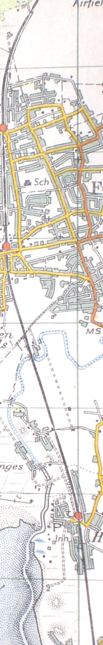
Reproduced from the 1961 Ordnance Survey map.
Click here for the line southwards to Hall Road...
Copyright J K Wallace, t/a 'Hall Royd Junction' 2013-2023 email: Hall Royd Junction
7 Portobello Close, Chesham, Bucks. HP5 2PL, UK
tel: +44 (0)7513 412880